A short story about a run that has been on my wish-list for a very long time: Bob Graham Round. A loop in the English Lake District during which you have to pass 42 summits in less than 24 hours. Very nice and a though challenge. Depending on the route you chose precisely the distance is a bit over 100km during which you have to climb (and descent of course) 8200m.
This is the list of the summits that one should pass:
1 Skiddaw
2 Great Calva
3 Blencathra
4 Clough Head
5 Great Dodd
6 Watson’s Dodd
7 Stybarrow Dodd
8 Raise
9 White Side
10 Lowerman
11 Helvellyn
12 Nethermost Pike
13 Dollywagon Pike
14 Fairfield
15 Seat Sandal
16 Steel Fell
17 Calf Crag
18 High Raise
19 Sergeant Man
20 Thunacar Knott
21 Harrison Stickle
22 Pike O’ Stickle
23 Rossett Pike
24 Bowfell
25 Esk Pike
26 Great End
27 Ill Crag
28 Broad Crag
29 Scafell Pike
30 Scafell
31 Yewbarrow
32 Red Pike
33 Steeple
34 Pillar
35 Kirk Fell
36 Great Gable
37 Green Gable
38 Brandreth
39 Grey Knotts
40 Dale Head
41 Hindscarth
42 Robinson
And this is what it looks like on a map:
Below you can find some pictures of the part between Green Gable and Harrison Stickle that I took during trainings in July 2010. They give a good idea about the kind of terrain you can expect on the loop. I marked the different summits with numbers. Most of the pictures are clickable (especially the panoramic ones) allowing you to see all the details. A red line is the route that I ran, a green line is the BGR route and a blue line is the course of the Lakeland100.
I start with a view from Styhead Tarn. From this point I climbed Green Gable.
Looking back during the climb you can see Great End (26) and the Scafells. This picture is taken from the grassy slope on the previous picture but evidently looking in the other direction:
On the top of Green Gable (37) I was faced with a thick fog. This is what the surface looks like in the direction of Great Gable (36, invisible in the fog):
The summit of Great Gable is also very rocky and not so easy to find in the fog.
Once past Great Gable, I descended towards Beck Head. As soon as I came out of the clouds, I had this view:
From a bit lower you can see the Wast Water on the left hand side as well. Of course Kirk Fell (35) where I am heading now is dominating the picture.
The summit of Kirk Fell was again cloud-covered but the downhill towards the Black Sail Pass offers another great view. The black dot is the position from which I took the next picture. Steeple (33) is greyed out as it is behind the ridge and hence invisible.
Then we look back from the climb up the Pillar just before entering the clouds. So this picture is taken from the previous black dot and the previous picture is taken from the black dot in this picture. Makes sense, huh?
The summit of the Pillar was in the clouds so I can not show you a nice view from there. Descending the Pillar and getting out of the clouds again, the next picture was the view. The central summit is Black Crag, which is for some reason not counted as a summit even though you basically have to pass it during the BGR. The same holds for Scoat Fell (the rocky plateau behind Black Crag and to the left of the Steeple (33)). Both of them are higher than both Red Pike and Steeple, so I fail to see why the BGR doesn’t count 44 summits. Getting to the Steeple is basicly an out and back section from Scoat Fell.
Then, approximatily the same view, but now I passed Black Crag. You can see that the surface offers here some very great running. Scoat Fell is now nicely visible, but as I told you, it doesn’t count.
A nice 360 degree view from Steeple. You can see the ridge along Black Crag leading to the Pillar (still in clouds). The rest of the BGR is hidden behind Scoat Fell. What you see in the rest of the picture is not BGR. It is nice however.

Then, another 360 degree view, but this time from Red Pike. Here you can see a lot more of the BGR course. The greyed out numbers are summits that are hidden from view by forground mountains.

Going down Red Pike you have a nice view on Yewbarrow. I climbed Yewbarrow by Stirrup Crag, but I understood that it is better to stay under the crags.
Now a view from Dore Head (the saddle between Red Pike and Yewbarrow). It is nice to see all the summits around the valley. That’s where I came from.
When I was on Yewbarrow another cloud blocked my view. In stead of shortcutting to Wasdale, I descended to Bowderdale. From there I had my only view on a cloudless Scafell summit.
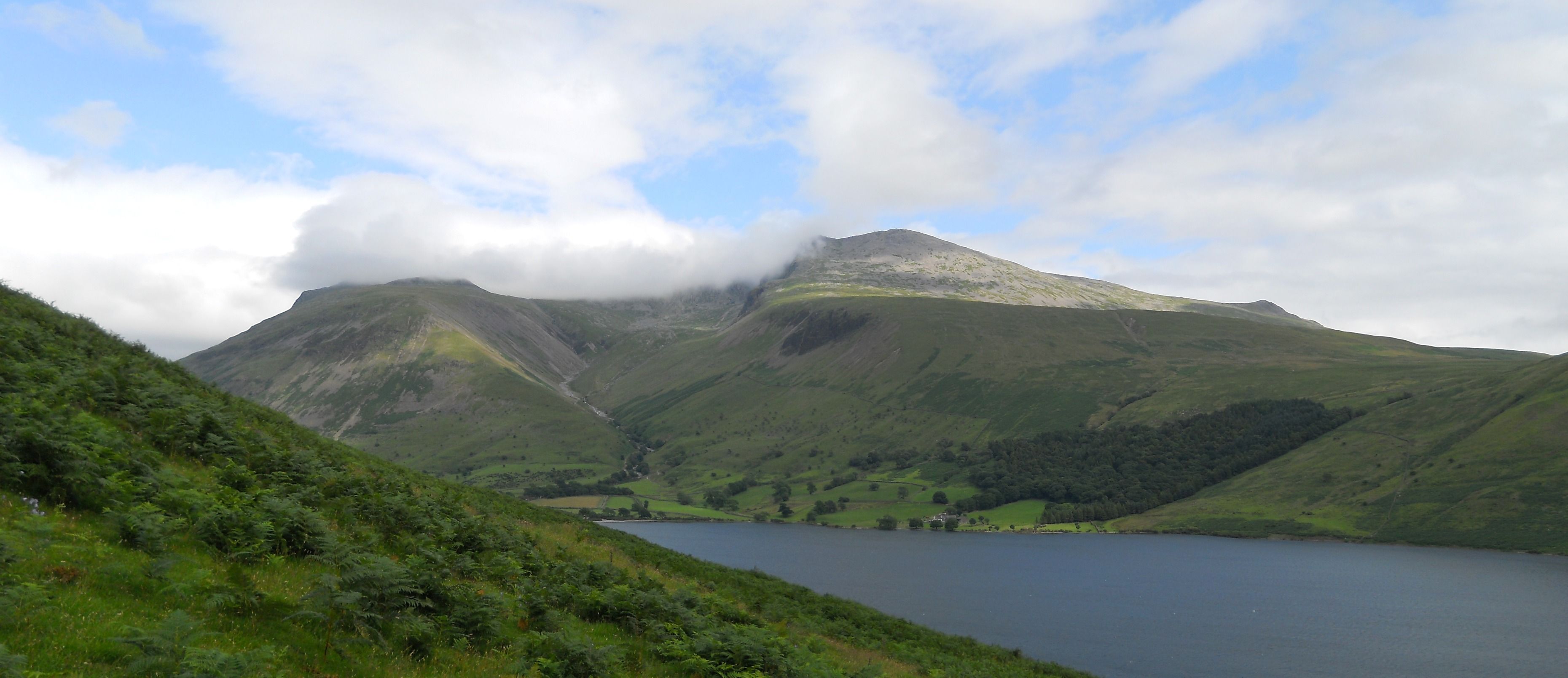
Oh wonder, when I was on Scafell it was cloudless as well. So I had this 360 degree view. See the cloud? Yeah, that’s Scafell Pike in there.

From Scafell on, I was in the fogs and afterwards in darkness, so I don’t have any nice views from this part of the run. But since this is one of the most touristical parts of the Lakes it can not be difficult to find a few good ones.
Now I make a little jump to Bowfell. This is what going up Bowfell looks like. Rather difficult footing if you don’t know where the grassy lines are.

From Bowfell you have a great view. This shows all 360 degrees around.

And according to me you can see a lot more summits. For this reason I have made an intermediate image, where I indicated all summits that I could identify. There might be mistakes in the most remote ones, but do not hesitate to correct me if you know the area very well.
Descending Bowfell, I get the first view of Rossett Pike. Some more peaks are visible than those that I indicated but you can surely identify them yourself with the help of the Bowfell panorama. The lake is Angle Tarn.

On Rossett Pike, I took another 360 degree view which is mainly dominated by the nearby higher Bowfell. I did not indicate the Clough Head – Helvellyn range that is visible in the right hand side of the image.

After Rossett Pike, I make the contouring towards Pike of Stickle. From Pike of Stickle you have yet another great 360 degree view.

My last summit is Harrison Stickle. There you have another nice 360 degrees view. I made again an intermediate image to show as many summits as I could identify, especially the Helvellyn range.

So, this should give you some idea of the terrain of the BGR. From Harrison Stickle I ran down the Dungeon Ghyll, so that was it.
bonne chance pour cette année!