Once upon a time in the West… a gang of runners came together for a little run in the mountains around Silverton. For me, this meant a long day of flying to Grand Junction with intermediate stops in London and Denver. From Grand Junction there was a two day bicycle ride into the San Juan Mountains left. Just before arriving at Silverton, I had my only real altitude test: the climb of the Red Mountain Pass (3358m/11018ft). Climbing a mountain pass with a heavy bike is always a bit suffering, but it didn’t feel any worse than climbing a pass in the Alps (where passes are much lower). That gave me some confidence that I would be able to manage the altitude. Altitude was anyhow the major concern for someone like me, arriving from sea level (ok, I’m lying; I live at 15m/50ft of altitude) only shortly before the race. After those two days of cycling, I arrived in Silverton on Monday late afternoon, installed my little Hardrock Base Camp near the banks of the Animas River and went in the evening to Charlie’s House. According to the preliminary course marking schedule there was only one day of course marking left, so that would be my only opportunity to see something of the course. Charlie was very kind, but had to disappoint me: they worked quickly on the course marking and had just finished everything. He suggested me to run the last miles of the course to get an idea of what it looks like and that sounded like a plan.
On Tuesday I followed his advice and ran up and down to the timberline. That gave me some idea of what to expect from the footing and trail markers along the course. The footing was better than I expected it to be, and for the trail markers it became clear that I should stay awake the whole way. The markers were rather sparsely placed, so missing a single one of them would mean getting of the course. This was the only part of the race course I saw before the start. The other almost 100 miles would remain a surprise for me until race day. I still did not really know what to expect from the race.
The rest of the day was spent hanging around and studying the course. On Wednesday and Thursday the hanging around and studying continued, with the addition of checking in, going to Memorial Park and finding out what a Pot Lick is, going to both loooooong and short briefings and preparing drop bags.
On Friday morning the alarms (plural, I had two of them to be sure I would wake up) in my tent went of, I had a quick breakfast (pasta prepared the evening before) jumped into my running clothes and cycled to the Silverton High School Gym. After watching a while the runners running around (that’s what runners do in the end) and whishing the best out there to some fellow runners, Dale called us out of the gym, grouped his troops and sent us with a little countdown up the mountains. This was it. We were running the Hardrock.
From the very start one crazy guy (Kyle) took of as a rocket. Behind him, we took things a little more relaxed. Running out of Silverton, passing the Nute Chute and crossing Mineral Creek went easily and smoothly. Than it was time to start our first climb of the race. In the lower parts of the climb I could easily follow the runners around me. Higher on the slope my breath started to sound like the Durango-Silverton steam train. I lost a little ground but could hang on and during the downhill even overtake them. Lessons of that first climb: downhill goes fine, uphill a bit less, course finding is not that hard, but sometimes you have to look around for a moment.
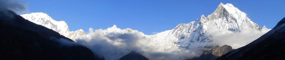
After the gentle downhill and a river crossing we went up again. The stop at the KT aid station didn’t take much time so we launched ourselves on the traverse. This is one of the flattest parts of the course allowing us even to run once in while uphill. Then, the crossing of the Ice Lake Falls was not problematic. During the briefing we had been warned to take no unnecessary risks on this part. With a little caution it even wasn’t that difficult. After this passing the track went up again. And again I started to feel like the Durango-Silverton steam train. The higher we went, the more I slowed down. In the rocky part near the summit of Grant Swamp Pass my head started to feel like someone was hitting it with a hammer. Maybe a little more acclimatization would have been a good idea. At the top of the pass my struggle continued after a short admiration of the amazing views. The steep scree descent went a little uncertain. After that I had some troubles in staying on course and consequently in picking up the pace. Only below timberline my pace went up again and I started to run a good downhill into Chapman.
A quick stop at Chapman and I started to attack Oscar’s. Going up the endless switchbacks felt like a copy of climbing Grant Swamp Pass. The higher I got, the more I started to resemble the Durango-Silverton steam train and the more Mr. Altitude started to hammer my head. I don’t know who Oscar was or is, but during that climb he certainly was not my friend. There was a lot of snow on Oscar’s Pass, slowing me further down. Like the climb, the descent was a copy of Grant Swamp Pass. Slow in the beginning, but speeding up as I reached lower altitude. Once I approached timberline, even the most technical parts went as a piece of cake. In the end I found myself pondering into Telluride. My status had shifted towards “bad” during uphills and “good” during downhills.
Telluride is just a small town with little to see except mountains, so I didn’t stay very long and went out again. It starts to get boring, but in the beginning I was able to keep up the pace. But the higher I got, the more I ran into troubles. Not the feeling of having my head hammered this time, however. The spectacular traverse between Mendota Saddle and Virginius Pass was more crawling than running, but in the end I arrived at Kroger’s Canteen. Because it was rather windy, I didn’t stay long up there either. From Kroger’s there was a rope to help us descend, but “Nobody used it this far” according to the aid station crew. And why would they. This was the perfect spot for a sitting glissade. Just take a seat on the steep snowfield and -jihaaaa- down you go. Great experience! A little further the snowfields were less forgiving: we had to traverse them, a glissade would mean a bad crash and than I entered the jeep roads. Same story as the other passes: I had some troubles in starting, but after a while was able to pick up the pace. Rushing down, making a quick stop at Governor aid station and I attacked the long jeep road to Ouray. This is one of the less appealing parts of the course. Something to pass as quickly as possible. On the road my nose started spontaneously bleeding. Something that happens rather often to me. It is totally harmless and stops spontaneously, but can look rather spectacular.
After this long downhill I arrived in Ouray with my face and hand covered with blood, causing some worries with the aid station crew and Dale. The conversation went something like this:
- “What happened? Did you fall?”
- “No, it just started bleeding, happens often to me. Do you have something to clean my face a bit? I don’t want to make a mess of the Hardrock when I kiss it.”
- “Sure, something else you need?”
- “Oxygen”
In Ouray I took a longer stop to eat a bit, changed clothes, took some warm clothes for the night, took my headlight… When hitting the road again, my legs felt a bit tired but soon recovered once I started running again.
Climbing up towards the Bear Creek Trail brought nothing new. Uphill I was worth nothing. At this point I was happy to do this part of the course during daylight. This seemed a rather spectacular trail to me and during darkness you can not see anything of that of course. And it was amazing to see! As the trail climbed higher my stomach started to feel a little upset. In the end this made me vomit a bit some mile or so before reaching Engineer aid station. My stomach felt better immediately afterwards. I must have eaten something wrong along the course. Once I was in the aid station, I took a long break near the warm campfire, eating two cups of soup to recover. By the time I left the aid station it was completely dark and I turned on my headlight. We were rather high now and this meant the usual thing to me: breathing hard and very slow progress. Even moving slowly, you get to the pass in the end. From the top of Engineer another jeep road showed me the way down. On this part I never was able to obtain a good feeling.
I was happy to arrive at Grouse Gulch aid station. This was another longer stop for me, to be fresh when attempting Handies. After eating a bit and putting on some warm clothes I took off again. Still nothing new to tell: in the beginning it went fine, but the higher I went the worse I felt and the slower I advanced. The climb up to American Basin-Grouse Pass offers no difficult footing at all, but as most passes before it made me sometimes stand still trying to get some oxygen in my lungs. But as long as you keep moving forward, you get to the top and that what happened in the end. Going down in American Basin was somewhat tricky. Frozen snowfields (some glissades possible, but most of them where better to run on) and boulders required a lot of attention. And you’d better make sure that you don’t lose the markers. I don’t know how one would ever find the course back in total darkness. The sighting was weird. In some directions and at different altitudes you could see the headlights of the other runners. But because of the winding trail you could not see how they got there. Nothing changed and the climb up Handies was a long shuffle. When passing another runner, who was in lack of energy, I give him a gel to help him out. A little later he past me at an (at that time for me) incredible speed. Wow, that must have been a strong gel I gave him. At the end of the long shuffle I stood on the top of Handies to see, well, basically a lot of darkness around me. That was it. The downhill required a lot of caution. It consists of a very steep slope with not always very clear footing and traversing a few steep snowfields. And you better don’t fall there because I have no idea where you would end up, but it might be somewhere deep. Once in de valley the trail became more obvious and I could even run it most of the time. Once past Burrows Park I could run most of the time on the jeep road. This is another rather boring part of the course. At dawn I ran into Chapman almost simultaneously with Kim. Chapman was the place to leave my headlight and change for some less warm clothes. As at most other aid stations, the soup tasted great over there.
With renewed courage I started the climb up Cataract. The lower parts of the valley went easily and fast. But when I was higher in the valley things became less obvious. I started my usual struggle with the altitude and the trail became less clear. When the trail started to wind up the left side of the valley, I doubted. Shouldn’t we simply go to the end of the valley? That’s what it looked like on the map anyhow, but unfortunately this is the only part of the course where the map is worth almost nothing. I started to look over the valley in the hope of seeing a marker near the river, went back a little part, but decided to follow the trail I was on. After some time that turned out to be the right decision when I saw a very welcome trail marker. From there on the climb was rather obvious. Once over the ridge the trail carried us over a rather gentle downhill, where I could run major parts. Down in Pole Creek, I managed to make a wrong interpretation of the course markers, causing me to divert back to the river. On the river bank I saw no trail marker (logic when you’re off course), realized I was wrong, took the map, started to return and saw Kim making the last climb towards the Pole Creek aid station. That was more than enough to get back on course and get to the aid station.
The climb towards Maggie-Pole Pass was tough for me. It is a gentle climb, but stays rather high (a problem for me since the beginning of the race) and my troubles with staying on the course had diminished the moral. My status changed towards “very bad” during the uphills and “moderate” during downhills. Somewhere during this climb I decided to take things gently from now on. It was clear to me, that I could easily finish before darkness and that a good performance was not possible with my limited acclimatization. In this state I crossed the Maggie-Pole Pass and started the downhill towards Maggie Gulch. There I took things easily, ate and drank a bit and attacked the climb towards Buffalo Boy Ridge. Man, that was a steep one. Simply going straight up the mountain. With my uphill status at “very bad”, it took me some time, but the work was worth it. Another amazing view unveiled on the top. I took the time to stand there a while and to be amazed. From Buffalo Boy Ridge it’s only a short descent to Stone Pass (including a glissade; wahoo) and the next climb begins. The climb up the Green Mountain Pass went slowly as usual, but it even didn’t take very long. Yet another great view, they keep coming. I took a break on top of the pass, sitting there for a while and looking around. In front of me the cross country traces of the runners that had passed here yet was clearly visible. The weird feeling of not wanting to finish came over me. Why should I rush to the finish? It is so nice up here? After a few minutes I stood up again and went down. In the beginning the surface was easy to manage, but the last part of the downhill into Cunningham is a place where you better don’t fall. I even don’t dare to think about doing that part at night. Still in the tourist mood I walked into the aid station.
This last aid station was again a great place to relax a bit, have some soup and drink a bit. When the aid station crew offered me an ice lolly, I realized those people were really spoiling me and found that is was time to hit the road one last time. While eating the ice lolly, I started climbing Little Giant. It was another long climb, which made me grasp for oxygen once more. After the endless series of switchbacks one steep part was left and then, well, it was time to sit down relax and enjoy the view. I still had that weird feeling of not wanting to finish. Maybe feeling “It was great, but I’m glad it’s all downhill now” would be more normal, but no, what I felt was really “To bad this is the last pass, I wish there would be another one and another one and…”. After absorbing all those amazing views, I stood up and started to walk down. Once I was on the jeep road a beautiful white goat stood suddenly in front of me. Shuffling closer didn’t seem to scare it away. To more runners approached, stopped and watched. Then two more. We stood there, five guys, just watching a snow white mountain goat. It didn’t move nor did we. As we couldn’t stay there the whole week, we started to walk and pass it as silently as we could. The goat was not interested at all. The rest of the course I simply walked down (ok, I had forgotten a little bit how far those last miles still were), not feeling any need to hurry and just thinking about the awesome experiences of the race. When approaching Kendall Ski Hut it was time to keep up appearance and finish running. I took of one last time, turned left at Reese Street, then right at the Gym and kissed that rock. As I wanted it, I came in just before the night fell.
The fastest man home was Kyle Skaggs in an impossible time of 23.23. I guess that reality made a mistake somewhere along the course… For my own race, it is clear that I should spend some more time at altitude before attempting a performance. I should try that next year to get unwinded.
I don’t have any pictures of the race, but the pics of my American trip (including a few pre-race and Pot Lick images) can be found on http://picasaweb.google.com/ptityeti/USA
Hardrock vs UTMB
People keep on asking how Hardrock compares to the UTMB. As I don’t like to answer the same question over and over again, I will write a comparison below. Please be a little patient.
Course: The distance and elevation gain/loss during both races are similar. This will make any major difference. However, I would say the UTMB course is easier in the sense that the end is relatively easy. Hardrock has challenging climbs until the end.
Altitude: This is one of the major differences. Hardrock is a lot (and I mean really a lot) higher. If you are at the high point of the UTMB, you are at the low point of Hardrock. I (coming from see level) can run the UTMB without much difficulty due to the altitude. Even without acclimatizing. As I found out this year, this it not the case at Hardrock.
Footing: Both courses are most of the time run on easy trails and sometimes even (jeep) roads. Hardrock offers more technical sections then the UTMB. I think of river crossings (which can be deep during a wet year), snowfield crossings (imagine traversing a 45° steep frozen snowfield at night), some cross country sections (with good footing) and very steep scree (try to find some pictures of Grant Swamp Pass). You won’t encounter any of them during the UTMB.
Course finding: During the UTMB it is next to impossible to get lost. As long as you stay awake, you should at all times see course markers and/or other runners. During Hardrock the course markers are sufficient, but rather sparsely placed. There can be multiple miles without any markers on the obvious parts. Studying the map and description and going to the looooong briefing are very useful if you do not know the course. It helps your peace of mind during the race.
Amount of runners: Let’s be clear. Hardrock has 140 entrants, while the UTMB has something like 2000 starters. Only this makes them totally different events. You won’t see a snake of lights at any pass during Hardrock as opposed to the very impressive one you see during the climb to Col des Seignes at the UTMB. What you prefer is up to personal taste.
Self sufficiency: The UTMB has a few aid stations more, then Hardrock (16 vs. 12). However, at the UTMB 6 aid stations have only drinks, while at Hardrock only one (Kroger Canteen) is really limited. Another difference is that the aid stations at the UTMB provide for immediate consumption (you can only have water to fill bottles/camelbacks), while they are more generous at Hardrock. More important is the number of drop bags. At Hardrock you can have a lot more drop bags (6) then at the UTMB (2). You will certainly be more charged during the UTMB since they have a very extensive list of obliged equipment. Somewhat exaggerated according to me. And last but not least, you are allowed to have a pacer (from Ouray on) at Hardrock, while this is strictly prohibited at the UTMB.
Landscape: Not really something that makes the running very different, but is was striking for me that in the Rockies I didn’t see a single glacier. If you would like to see glaciers, you should go to the UTMB.
I just wanted to give an overview of the major differences between both races, without judging too much on good or bad. My personal favourite is Hardrock, but I can accept that other people will have different opinions.